Dolomites Alta Via 1 Trek – 9-day Hut-to-Hut Hiking Tour in Italy
Chamonix – Zermatt crossing
The Alta Via 1 is one of the most iconic hut-to-hut treks in Europe, crossing the dramatic landscapes of the Dolomites in northern Italy. This UNESCO World Heritage mountain range is known for its limestone peaks, alpine meadows, and panoramic high-altitude trails.
This 9-day self-guided trekking itinerary follows the most scenic sections of the Alta Via 1, from Lago di Braies to Belluno, combining mountain huts, spectacular passes, and immersive alpine experiences.
Searching Availability...
🏔️ Why hike the Dolomites?
- One of the most scenic mountain ranges in Europe
- UNESCO World Heritage landscapes
- Authentic hut-to-hut trekking experience
- Well-marked long-distance trail
- Dramatic limestone peaks and panoramic views
📊 Key information
- Duration: 9 days
- Distance: ~120 km
- Hiking time: 5 to 8 hours per day
- Accommodation: mountain huts (rifugi)
👉 A perfect adventure for hikers looking for a multi-day trek in the Dolomites.
🥾 Difficulty & level
The Alta Via 1 is considered an Expert trek:
- long hiking days
- significant elevation gain
- some rocky and uneven terrain
👉 Suitable for hikers in good physical condition
👉 Previous trekking experience is recommended
👉 No technical climbing or via Ferrata required
🗓️ Best time to go
- Mid-June to late September
- Optimal conditions in July and August
- Varies depending on snow conditions at higher elevations early in the season
Alta Via 1 Dolomites - Detailed Itinerary (9 days)
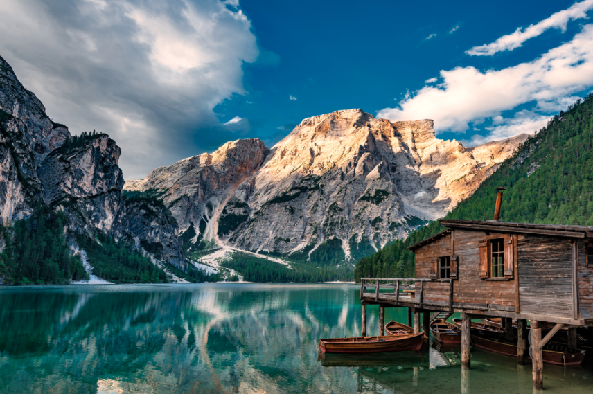
Your adventure begins with a private transfer from Cortina d’Ampezzo to the iconic Lago di Braies, famous for its crystal-clear turquoise waters and dramatic alpine setting.
After a short walk along the lake, you gradually ascend towards your first mountain hut. This opening stage offers the perfect introduction to the Alta Via 1, combining iconic scenery, gentle hiking, and an authentic alpine atmosphere.
👉 Overnight at Rifugio Biella
⏱️ 9 km • 📈 +1070 m / 📉 -235 m
From Rifugio Biella, the trail climbs steadily across rocky terrain before opening onto wide alpine landscapes within the Fanes-Senes-Braies Natural Park.
As the scenery softens, you descend into a peaceful valley leading to Rifugio Lavarella, surrounded by meadows and mountain streams.
👉 Overnight at Rifugio Lavarella
⏱️ 13.5 km • 📈 +850 m / 📉 -1130 m
One of the most spectacular stages of the Alta Via 1.
The trail winds through vast alpine meadows before climbing higher into the mountains, revealing dramatic views over the Dolomites. In the distance, the peaks of the Tofane massif rise sharply.
The final ascent leads to Rifugio Lagazuoi, perched at altitude, offering breathtaking 360° views over iconic peaks such as Marmolada and Civetta.
👉 Overnight at Rifugio Lagazuoi or Scotoni
⏱️ 13 km • 📈 +1700 m / 📉 -700 m
Today’s stage combines history and iconic landscapes.
After reaching Falzarego Pass, you’ll pass World War I remains, including tunnels and fortifications. The trail continues towards the impressive Cinque Torri rock formations.
A final ascent brings you to Rifugio Nuvolau (2,574 m), one of the most panoramic viewpoints of the trek.
👉 Overnight at Rifugio Nuvolau (or similar)
⏱️ 11.5 km • 📈 +745 m / 📉 -900 m
From Passo Giau, descend before continuing across rolling alpine terrain towards the Monte Pelmo region.
Known as the “Throne of the Gods”, Monte Pelmo dominates the landscape as you cross wide meadows where wildlife such as marmots can often be spotted.
👉 Overnight at Rifugio Staulanza or Città di Fiume
⏱️ 19.2 km • 📈 +690 m / 📉 -1470 m
This stage takes you around the base of Monte Civetta, one of the most impressive peaks in the Dolomites.
The trail alternates between alpine pastures, forest sections, and mountain passes, before reaching Rifugio Vazzoler in a wild and preserved setting.
👉 Overnight at Rifugio Vazzoler
⏱️ 15 km • 📈 +885 m / 📉 -945 m
A shorter but scenic stage through forests and alpine meadows.
Crossing the Civetta massif, you’ll enjoy beautiful panoramic views before reaching Rifugio Carestiato, a peaceful and secluded mountain hut.
👉 Overnight at Rifugio Carestiato
⏱️ 9 km • 📈 +630 m / 📉 -515 m
One of the most demanding yet rewarding stages of the trek.
After climbing towards Moschesin Pass, you are rewarded with stunning panoramic views before descending into the remote and untouched Val Pramper.
👉 Overnight at Rifugio Pramperet or Pian de Fontana
⏱️ 13 km • 📈 +695 m / 📉 -665 m
Your final day takes you down through forests towards the valley.
Leaving the remote Val Pramper behind, you gradually descend with beautiful views over the Val di Zoldo. The trek ends at La Pissa, followed by a bus transfer to Belluno.
👉 End of the trip
⏱️ 17.5 km • 📈 +860 m / 📉 -2265 m
The itinerary, refuges, distances, and elevation may vary depending on weather conditions and availability.
This is a self-guided trek. You will receive a detailed roadbook, maps, and GPX tracks, but you remain responsible for your decisions while hiking.
Prices - Dolomites Alta Via 1 Trek
👉 from 1375€ per person (self-guided trip)
What's Included
- 8 nights in dormitory-style accommodation in mountain huts
- 8 breakfasts and 8 dinners
- Private transfer from Cortina d'Ampezzo to Lago di Braies on Day 1
- Full travel roadbook
- Assistance from our team on site
What's Not Included
- Repatriation insurance (compulsory) and cancellation insurance (strongly recommended)
- Accommodation the night before departure (Day 0) and after arrival (Day 9)
- Transfers throughout the trip and transfers to Cortina d’Ampezzo and from Belluno
- Lunches, snacks, drinks and personal expenses.
- Anything not listed under "What's Included"
Optional Add-Ons (on request)
- Transfers to Cortina d'Ampezzo and from Belluno
- Accommodation in Cortina d'Ampezzo
- Accommodation in Belluno
Book your Alta Via 1 - Dolomites trek
FAQ - Trek Dolomites - Alta Via 1
No, the trek offered is self-guided (without a guide).
Typically 4 to 9 days, depending on your itinerary.
Yes, several months in advance 🙂
Practice makes perfect !
You can take day trips that offer an equivalent or more demanding level of difficulty with a backpack. You can also multiply experiences that consolidate your skills & abilities (diversify practice environments and modes of execution, acquire new skills like map reading, compass or GPS navigation).
And of course, always be aware of the outing you’re about to embark on.
A technical path is a trail with particularly uneven terrain and a very heterogeneous surface (tread, all types of terrain). The path is therefore less “rolling”, more irregular, and requires more attention and caution from the hiker.
Some of these technical passages can cause, when the ground requires it:
- The crossing of permanent installations (wired handrails, ladders, footbridges…).
- The use of technical equipment (use of a rope to protect a progression, use of crampons on hard snow).
- To be able to demonstrate ease of movement and technical skills (where and how to place one’s feet in order to progress with maximum safety).
- The use of knowledge and a technical skills based on years of experience (being able to adopt the best behavior and make the best decision).
The technical difficulty of a trail can apply to the entire itinerary or just specific sections, requiring greater focus and careful attention. Crossing technical paths demands more physical and mental effort, affecting the time needed to complete the route and the recovery required afterward.
All technical trails are manageable if you stay calm, methodical, and well-prepared, planning each step carefully before taking action.
When in doubt, it is best to consult a professional mountain guide, ensuring safe decisions and proper guidance for more challenging sections!
Discover also…
Ready to hike the Dolomites?
Contact us to plan your Alta Via 1 adventure: