CHAMONIX - ZERMATT CROSSING
Chamonix - Zermatt crossing:
Chamonix – Zermatt crossing
9 DAYS, SELF-GUIDED
Discover the Alpine Haute Route, by the trail, a long-distance hike linking two major Alpine capitals: Chamonix Mont Blanc in France, and Zermatt in Switzerland.
Here is a succession of authentic valleys, famous mountain passes, charming little villages and a multitude of glaciers, lakes and torrents tumbling down the slopes of shady forests!
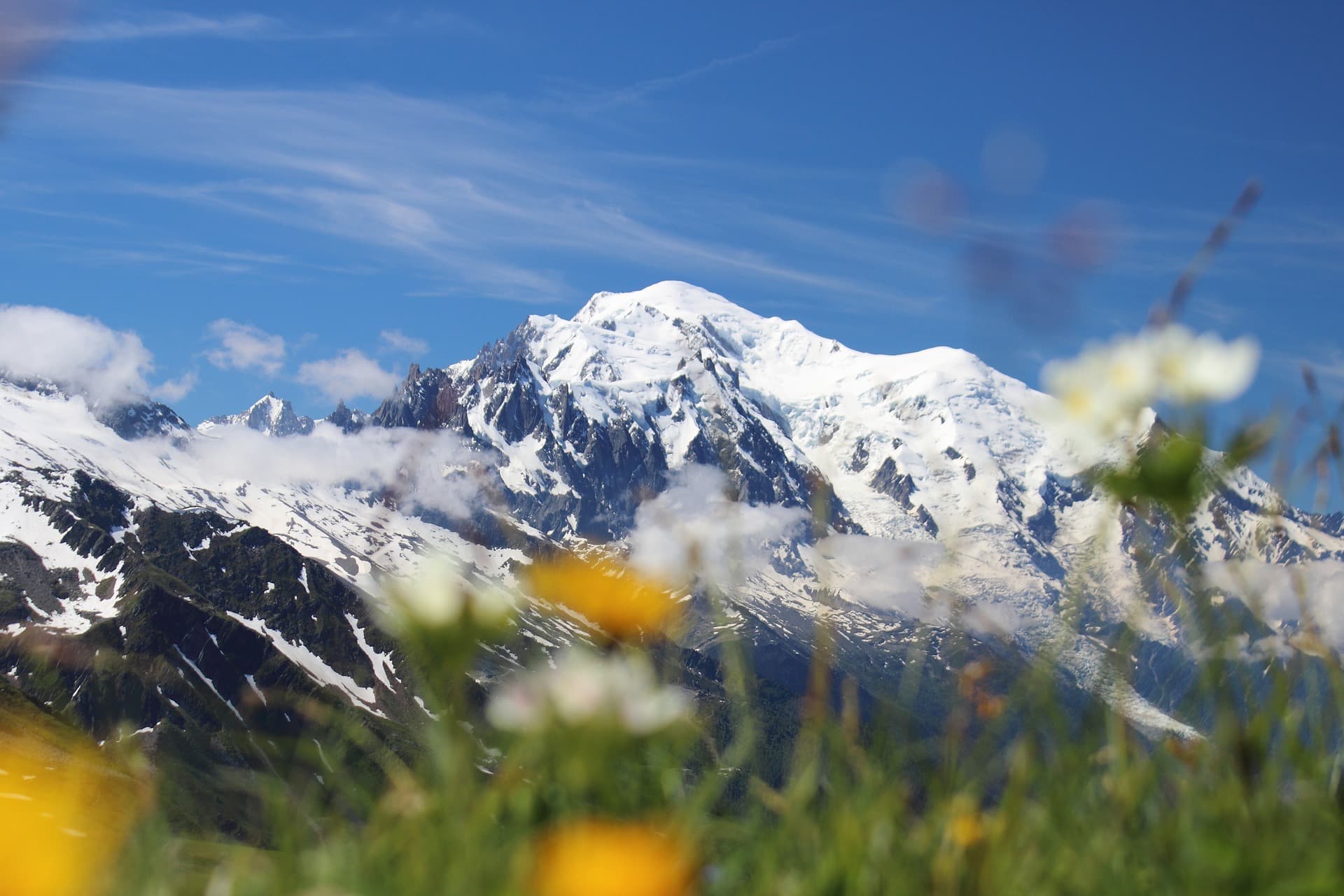
If the Haute Route by the glaciers is well known to mountaineers, hikers take a very different route. It is the “by the trail” version, which goes between 2000 and 3000m of altitude, in medium-altitude mountains, on diversified and non-glacial trails.
Want to find out more? Here’s a blog post about the crossing written by one of our customers.
Searching Availability...
Departure of the hike from the village of Montroc in the Chamonix-Mont-Blanc valley.
Day 1: Montroc – Trélechamp – Trient
The ridge of the “aiguillette des Posettes” is particularly esthetic and panoramic. The Mont-Blanc range, its main summits and the Chamonix valley offer breathtaking landscapes! The mountain pastures of Posettes and Balme are the last ones in activity near Chamonix. The crossing of the French-Swiss border is done by a path on the side of the mountain, through the alpine pastures of Catogne. The village of Trient is our destination.
Approximate distance : 11,5km – Elevation gain: 1000 m / elevation loss: 1200 m.
Day 2: Trient – Champex (via Bovine Alpine Pastures)
The day begins with a hike up to the Col de La Forclaz. The trail then goes through a beautiful larch forest and reaches the alpine pastures of Bovine, which overlook the upper Rhone valley and is located upstream from Lake Geneva in the Swiss Valais. You can also admire the range of the crag of the South as well as the counter forts of the Bernese Alps. Further east, the Pennine Alps (Valaisannes) welcome us with the Grand Combin massif. The “Bovine route” is used by farmers to guide their cattle through the mountains. The trail now goes down to the Plan de l’Au and finally Champex le Lac.
Approximate distance : 15km – Elevation gain: 850 m / elevation loss: 1000 m.
Day 3: Champex – Mille hut
From Champex-Lac, a lovely hike down through the forest, hillsides and small hamlets lead to the bottom of the Val d’Entremont and the village of Orsières located at the bottom of the Grand St Bernard pass. Here are the Valaisan Alps! A long climb on the western side of the Val d’Entremont is necessary to reach the crests of the Mont Brûlé which allows us to admire one last time the summits located at the north-east of the Mont-Blanc range. The trail reaches the Mille hut perched at 2473m of altitude, where you will stay overnight.
Approximate distance : 13km – Elevation gain: 1700 m / elevation loss: 700 m.
Day 4: Mille hut – Louvie hut
This is a long but easy stage in beautiful open landscapes. From the Cabane de Mille overlooking the Val d’Entremont to the Cabane de Louvie, overlooking the Val de Bagnes. These two huts offer wonderful panoramas. A very pleasant track, crossing to the Brunet hut, and then descending into the Val de Bagnes. From the village of Fionnay, the path goes up towards the Louvie hut and its magnificent lake. From there you will be able to see the reflexion of the immense Corbassière glacier.
Approximate distance : 18km – Elevation gain: 1200 m / elevation loss: 1400 m.
Day 5: Louvie hut – Prafleuri hut (via the Louvie and Prafleuri passes)
Two passes in the program for the day. First the Louvie pass (2921m), then the Prafleuri pass (2939m). The Grand Desert is waiting for you. Located between the two passes, the Grand Desert is a vast plateau made up by moraines and rocks that the glaciers have left here and there. The atmosphere here is very mineral, punctuated by lakes, cairns and beacons that will guide your crossing. From the Prafleuri pass, the trail goes down to the hut, where you will spend the night.
Approximate distance : 14,5km – Elevation gain: 1050 m / elevation loss: 1150 m.
Day 6: Prafleuri hut – La Grande Dixence dam – Evolène (via Col de la Meina)
For today itinerary, we prefer to avoid the pass of Riedmatten or the Pas de Chèvre. These two sections are both technical and aerial. Both of them can represent a major difficulty for all those who are not sure of their footing in the unstable rocky terrain and/or fear the climbing of high vertical ladders.
Our trail leaves the Grande Dixence dam and descends into the Hérémence valley to the place called “Motôt”, a point at 1905m. The path crosses the torrent of Merdéré and reaches the alpine pastures of Novèlé (2082m) much later. The crossing of the Meina pass (2702m) allows to switch to the Val d’Hérens. The descent from the pass reaches the very pretty hamlet of La Meina. From here, a chairlift will facilitate the descent to the village of Lannaz.
Approximate distance: 19 km – Elevation gain: 1050m / elevation loss: 1560m.
Alternative : Prafleuri hut – Les Dix lake – Evolène
If you feel comfortable and you prefer to follow the classic route you can cross the Riedmatten pass (2854m).
Day 7: Evolène / La Sage – Zinal (via Col de Thorens et Lac de Moiry)
From La Sage in the Val d’Hérens, head towards Zinal. You will first pass by the Col de Torrent. The view of the Moiry lake dam with its amazing colors is wonderful. You will then hike down to the lake by crossing the alpine pastures of Thorens. From the dam, the local shuttle service will take you from Moiry to Zinal where you will spend the night.
Approximate distance: 11 km – Elevation gain: 1200m / elevation loss: 700m.
Day 8: Zinal – Gruben (via Col de la Forcletta)
The climb to the Col de La Forcletta is long and diversified. A steep path in the forest leads to a long, pleasant balcony above the Val de Zinal, and then to a welcoming alpine pasture area on the final steep slope. The hike down into the Turtmanntal (Val Turtmann) is like a jump out of time. Inaccessible in winter, this is the wildest valley in the Valais. In the background you will glimpse the Augstbordpass, that you will cross the next day, as well as the Turtmann glacier surrounded by the Bishorn on one side and the Weisshorn on the other.
Approximate distance: 24 km – Elevation gain: 1500 m / elevation loss: 1350 m.
Day 9: Gruben – St Niklaus – Zermatt
The ascent to the Augstbordpass (2892m) is long: forest, alpine meadows, grassy slopes, stones and rocks… This is the last difficulty of our journey. The passage of the pass offers a spectacular view. Here is the Val de Zermatt and the Mischabels massif. The descent goes in the valley under the pass until the intersection, marked 2095m. The path continues on the right, on a rather steep side of the Twära mountain, in direction of the suspended hamlet of Jungu (1954m). From there a small cable car takes us down to St-Niklaus. A train connection takes us to Täsch, and the next one to our final destination, Zermatt.
Approximate distance: 13 km – Elevation gain: 1100m / elevation loss: 1000m
Note: the itinerary, distances and altitudes may vary slightly for many reasons beyond our control, including weather and terrain conditions.
Please also be aware that self-guided trek involves your own responsibility for the route you choose and the choices you make on the trails. We will provide you with a roadbook, map and GPX tracks but you will be hiking every day on your own and we cannot be responsible for the decision and events that may occur during your hike.
Included:
- Accommodation: 8 nights (7 nights in dormitory-style accommodation and 1 night in private accommodation).
- Meals: 8 breakfasts and 7 dinners (not included in La Sage).
- Travel information: roadbook, GPS tracks and map for 2 people.
- Assistance from our team on site.
Not Included:
- Repatriation & Rescue (mandatory) and Cancellation (highly recommended) insurances.
- Accommodation for one night before the trip (Day 0) and one night after the trip (Day 9).
- Dinner on Day 6
- Transfers throughout the trip and transfers to Chamonix and from Zermatt.
- Lunches, snacks and personal expenses.
- Everything not indicated in the “included” section.
Options on request: contact us.
- Transfers to Chamonix and from Zermatt.
- Accommodation in Chamonix and/or Zermatt.
Duration: 9 days | Level: Expert | Period: from mid-July to September | Group size: unlimited | Trip: self-guided | Destination: France/Switzerland.
Advice from our team :
The Chamonix – Zermatt trek is a demanding route that requires mountaineering skills and a certain experience. A training beforehand and a good physical shape are necessary.
Useful link: blog article – everything you need to know about the Chamonix-Zermatt crossing.
F.A.Q.
Chamonix Zermatt crossing
A technical path is a trail with particularly uneven terrain and a very heterogeneous surface (tread, all types of terrain). The path is therefore less “rolling”, more irregular, and requires more attention and caution from the hiker.
Some of these technical passages can cause, when the ground requires it:
- The crossing of permanent installations (wired handrails, ladders, footbridges…)
- The use of technical equipment (use of a rope to protect a progression, use of crampons on hard snow)
- To be able to demonstrate ease of movement and technical skills (where and how to place one’s feet in order to progress with maximum safety)
- The use of knowledge and a technical skills based on years of experience (being able to adopt the best behavior and make the best decision)
The technicality of a path can be represented on the entire itinerary or only a portion of it. Its crossing requires a more sustained effort of concentration. In fact, the energy spent on the expenditure linked to the physical and psychological effort is more important. This has an impact on the time needed to complete the route and should be taken into account when preparing the trip. Of course, the same applies to recovery time.
All technical paths can be crossed, as long as you are calm, analytical, and methodical. Nothing is impossible as long as you have been expecting it, preparing it and now that you are taking action!
When in doubt, call on a professional who can guide you in the choices and decisions to be made. This is by far the best way to go!
This comes down to defining what an expert is!
She/he is the one who knows her/his practice very well and who can attest to her/his skills. Trained, knowledgeable, already experienced in some significant experiments, her/his objective is to improve her/his art in practice by multiplying the experiments as often as possible.
If you define yourself as such, then do not hesitate to consult all our programs that mention the expert level.
When in doubt, call in a professional!
These are two hiking itineraries of several days each, on mountain ranges subject to the same coercion and dynamics. The mountain environment presents the same characteristics (ecosystem, weather/climate, relief and landscapes…). These two hikes are therefore as beautiful as each other, however, the Chamonix – Zermatt is more difficult than the Tour du Mont-Blanc, because :
- The very large number of people on the TMB has encouraged the formation of wider trails. The path is much more “rolling”, convenient and “smoothed” by the passage of hikers, mountain bikers, pack animals). Walking is easier on the TMB trails.
- The Chamonix-Zermatt trails cross passes that are higher in altitude (between 2600m/8500ft and 2900m/9700ft). The physical effort is more demanding and the climatic constraints potentially more severe.
- The itinerary presents stages or portions of stages that are more technical (the crossing of the Grand Desert for example, scree slopes and desert terrains over 2600m/ 8500ft where the marking are minimalist painting on rocks ). Overall, the trails are narrower, and there are more exposed passages that require more physical and psychological effort.
- The Chamonix – Zermatt program offers a much greater daily vertical drop and total distance covered. The management of the effort and the recovery time requires more experience.
In fact, one must know one’s own aptitudes (meaning you know your limits and your level) and always prepare your hike (check the weather the day before, the itinerary / distance, elevation, … make sure you have the appropriate equipment).
Practice makes perfect ⚒
You can take day trips that offer an equivalent or more demanding level of difficulty. You can also multiply experiences that consolidate your skills & abilities (diversify practice environments and modes of execution, acquire new skills like map reading, compass or GPS navigation).
And of course, always be aware of the outing you’re about to embark on.
Find out all about the traverse – right here!
Discover also…