Tour du Mont Blanc Hike – 6 Days, Self-Guided (France · Italy · Switzerland)
6 days · 5 nights · 3 countries · Depart from Les Houches · No guide required
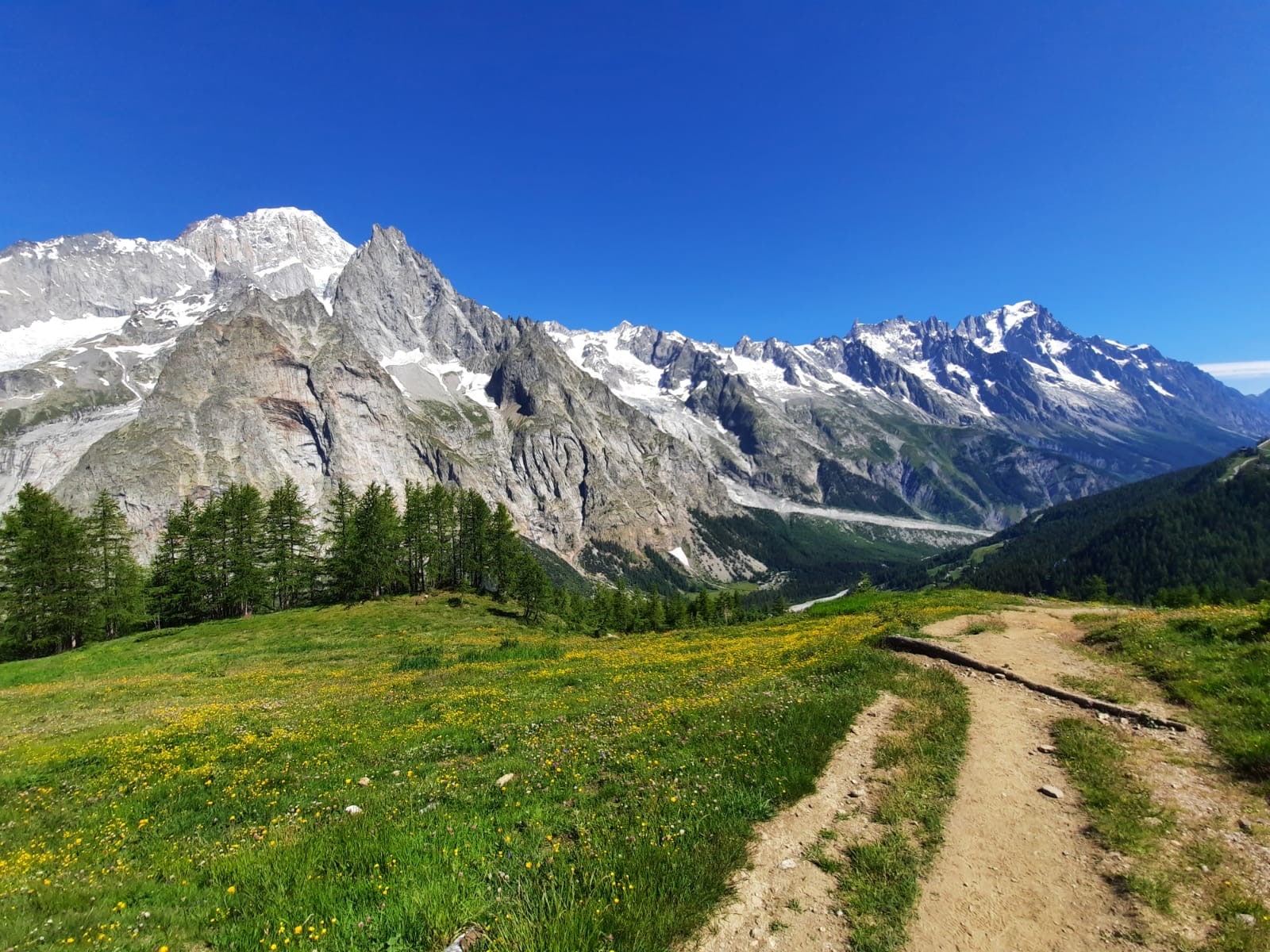
The Tour du Mont Blanc, Self-Guided – One of the World's Greatest Treks, Fully Organized
The Tour du Mont Blanc (TMB) is one of the most iconic long-distance hikes in the world. Spanning roughly 106 miles (170 km) across three countries — France, Italy, and Switzerland — it takes you through some of the most dramatic Alpine scenery on Earth: hanging glaciers, passes above 8,000 feet, remote mountain villages, and the wild western face of Western Europe’s highest peak.
Every summer, thousands of hikers from around the world come to walk the TMB. And yet, organizing it from abroad is genuinely complex: the best huts and refuges fill up months in advance (often as early as January), luggage transfers need to be coordinated across three countries, and local bus schedules in Italy and Switzerland only run in high season.
With Nuyama, you walk the Tour du Mont Blanc on your own terms — no guide, no group, no fixed pace. We handle everything else: accommodations booked well ahead of the season, door-to-door luggage transfers, and a detailed roadbook with GPX tracks so you always know exactly where you are. You just walk — and take it all in.
🗺️ Day-by-day route guide, GPX files for every stage, and an IGN topographic map — everything you need to navigate confidently on your own.
🎒 Add luggage transfer to your booking and your bag moves from hut to hut while you hike. Walk light. Arrive happy. (Soft bag, max 33 lbs / 15 kg.)
🏠 Our Les Houches-based team selects and reserves your accommodations months before your trip — so you never have to worry about finding a bed after a long day on the trail.
Why Book Your Tour du Mont Blanc with Nuyama?
Doing the Tour du Mont Blanc self-guided sounds simple. In practice, it means securing mountain hut reservations months in advance (the best ones sell out fast), coordinating luggage transfers with separate operators in France, Italy, and Switzerland, and figuring out which local buses actually run in June vs July.
Our team is based in Les Houches — at the foot of Mont Blanc. We know the TMB in every detail: the stages with the best views, the accommodations that are actually worth it, the weather windows, the shortcuts when conditions change. We do this every season, for hikers coming from the US, Canada, Australia, the UK and beyond.
When you book with Nuyama, you’re not buying a list of reservations. You’re buying the peace of mind that comes with knowing every detail has been taken care of — so your trip starts the moment you lace up your boots, not months earlier at a spreadsheet.
- Les Houches-based team, in the Chamonix valley, with first-hand knowledge of every stage
- Accommodations reserved months in advance — no scrambling for beds
- Full trip support from our on-the-ground team throughout your stay
- Trusted by hikers from the US, Canada, UK, Australia and beyond
Searching Availability...
Tour du Mont Blanc Itinerary – 6 Days Step by Step
Your Tour du Mont Blanc begins. The cable car up from Les Houches (one-way included) rises above the treeline in minutes — and suddenly you’re sharing the platform with mountaineers heading for the summit of Mont Blanc.
From the top of the Bellevue cable car, the trail takes you across the high slopes beneath the Bionnassay glacier, one of the most impressive glaciers on the Mont Blanc massif. The path is wide and well-marked, with the white-and-red GR trail markers that will be your constant companions for the next six days.
The Col du Tricot (6,562 ft / 2,000 m) is today’s high point — and your first real reward. The view opens up over the entire Contamines-Montjoie valley below, and on a clear day you can already see the ridgeline you’ll be crossing tomorrow.
From the col, a good descent leads you through the Chalets de Miage — a cluster of traditional Alpine farms — and down into the village of Les Contamines-Montjoie, where you’ll spend your first night.
⏱️ 11 km (6.8 miles) • 📈 +640 m (+2,100 ft) / 📉 -1280 m (-4,200 ft)
Today is the biggest day on the route — and one of the most rewarding. From Les Contamines, the trail follows the valley floor before climbing steadily through forest and open pasture toward the high mountains.
You’ll pass through Notre-Dame-de-la-Gorge, a small chapel tucked at the end of the paved road, and continue up past the Refuge de Nant Borrant and the Refuge de Balme — both good spots for a coffee or a snack before the final climb.
The Col du Bonhomme (7,641 ft / 2,329 m) is the high point of the day and one of the best picnic spots on the entire TMB. Stop here, eat something, and take in the view — you’ve earned it. The pass marks the transition between the northern Alps and the wilder terrain ahead.
The afternoon descent into Les Chapieux is long but gradual, following a broad ridge before dropping into the quiet hamlet where you’ll spend the night.
⏱️ 19 km (11.8 miles) • 📈 +1360 m (+4,460 ft) / 📉 -970 m (-3,180 ft)
Today you cross into Italy — and the landscape shifts completely.
From Les Chapieux, the trail climbs steadily through the Vallée des Glaciers toward the Ville des Glaciers, a remote cluster of farm buildings at the base of some of the most dramatic glacier scenery on the route. The path then rises toward the Col de la Seigne (8,432 ft / 2,570 m), the border between France and Italy.
The view from the col is extraordinary: you’re standing on the edge of the western face of Mont Blanc — the wildest, most isolated side of the massif. No ski resorts, no cable cars. Just glaciers, rock faces, and silence. Turn around for one last look at France before descending into the Val Veny.
The descent takes you down to La Visaille, at the snout of the Miage glacier, where you’ll pick up a local bus to Courmayeur (free). Courmayeur is one of Italy’s most elegant mountain towns — take the evening to explore, have dinner on your own, and enjoy the change of scenery.
⏱️ 20 km (12.4 miles) • 📈 +1060 m (+3,480 ft) / 📉 -970 m (-3,180 ft)
This morning, a local bus takes you from Courmayeur up the Val Ferret to Arnouva — the trailhead for today’s biggest climb. Before you set off, stop at the Rifugio Elena for an espresso. It might be the last proper Italian coffee for a while.
The climb to the Grand Col Ferret (8,323 ft / 2,537 m) is steady and rewarding. This is the highest point of the entire Tour du Mont Blanc, and the views from the top are among the most spectacular of the trek. Before you cross into Switzerland, turn around: the entire Italian side of the massif — Val Ferret, the Grandes Jorasses, the Aiguille de Leschaux — stretches out behind you.
The descent into Switzerland is long (almost 5,000 ft / 1,500 m of total drop by the time you reach Champex), but the terrain is excellent and the Val Ferret suisse is beautiful. You’ll pass through the village of La Fouly, where you’ll catch a local bus to Champex-Lac — a peaceful Swiss village set around a small mountain lake, where you’ll spend the night.
⏱️ 15 km (9.3 miles) • 📈 +820 m (+2,690 ft) / 📉 -985 m (-3,230 ft)
A gentler day after the big efforts of Days 2 and 4. From Champex-Lac, the trail begins with an easy, almost flat stretch along the old “bovine route” — the ancient path that herders once used to move their cattle between valleys. It’s a pleasant start: green hillsides, cowbells, wide-open skies.
As the morning progresses, the terrain becomes more varied. The trail climbs through forest and then opens out onto a series of viewpoints overlooking the Rhône Valley and the town of Martigny far below — a reminder of how high you’ve climbed over the past four days.
The afternoon descent takes you down to the Col de la Forclaz and then into the village of Trient, a tiny hamlet tucked between steep wooded slopes. A quiet, restorative evening before your final day.
⏱️ 15 km (9.3 miles) • 📈 +830 m (+2,720 ft) / 📉 -1020 m (-3,350 ft)
Your last day on the Tour du Mont Blanc — and the mountain saves some of its best scenery for the finale.
From Trient, the trail climbs steadily through forest before breaking out into open alpine terrain on the way to the Col de Balme (7,218 ft / 2,200 m), the final pass of the trek and the border between Switzerland and France.
The panorama from the Col de Balme is extraordinary: the entire Mont Blanc massif laid out in front of you — from the Aiguilles Rouges in the foreground to the summit you’ve been circling for six days. Take your time here. This is the view that makes the whole trek worth it.
The descent into France is long but gentle, dropping through the ski area of Balme and down to the hamlet of Montroc in the Chamonix valley. From Montroc, a short local bus ride brings you back into Chamonix — and to the end of your Tour du Mont Blanc.
Six days. Three countries. One of the world’s great hikes. Well done.
⏱️ 14 km (8.7 miles) • 📈 +1130 m (+3,710 ft) / 📉 -1040 m (-3,410 ft)
Note: distances, elevations, and timings are approximate and may vary due to weather, terrain, or route adjustments beyond our control.
Self-guided trekking means you are responsible for your own route decisions on the trail. We provide a detailed roadbook, GPX tracks, and a topographic map — but you will be hiking independently each day. Nuyama cannot be held responsible for decisions made on the trail or events that occur during your hike.
In case of doubt or difficulty, always prioritize safety. Turn back if conditions change. Our team is available throughout your trip if you need guidance.
What's Included
- Accommodation: 4 nights in dormitory + 1 night in private accommodation in Courmayeur
- Meals: 5 breakfasts + 4 dinners (dinner not included in Courmayeur)
- Lift ticket: Bellevue cable car on Day 1 (one way)
- Full travel roadbook
- Assistance from our team on site
- Bags transfers throughout the trip, if you select this option
What's Not Included
- Repatriation insurance (compulsory) and cancellation insurance (strongly recommended)
- Accommodation the night before departure (Day 0) and after arrival (Day 6)
- Transfers throughout the trip and transfers to/from Chamonix
- Dinner on Day 3 in Courmayeur
- Lunches, snacks, drinks and personal expenses
- Anything not listed under "What's Included"
Optional Add-Ons (on request)
- Transferts to & from Chamonix
- Accommodation in the Chamonix valley
Book Your Tour du Mont Blanc Trek
☀️ What is the best time of year to hike the Tour du Mont Blanc?
- Mid-June to September
- Optimal conditions in July and August
- Varies depending on snow conditions at higher elevations early in the season
The Tour du Mont Blanc hiking season runs from mid-June to late September. July and August are the prime months: snow has melted from most passes, all local buses in Italy and Switzerland are running, and the weather is most reliable. June and September are quieter and equally beautiful, but some high passes may still carry snow, and certain shuttle services require a taxi (at additional cost). One important note: accommodations fill up fast. Book early.
🧭 Can you hike the Tour du Mont Blanc without a guide?
Yes, and that’s exactly what our self-guided program is designed for. The TMB is a well-marked trail that experienced hikers can navigate independently. We rate this trek as “Elementary” difficulty, which means challenging, not easy: over 6 consecutive days, you’ll cover approximately 95 km (59 miles) with over 34,000 ft (10,500 m) of cumulative elevation. We provide a detailed roadbook, GPX tracks, and a topographic map so you always know where you are. No guide required — just solid hiking fitness and experience.
💰 How much does an organized Tour du Mont Blanc cost?
Organizing the TMB yourself is possible, but it takes significant time and local knowledge — especially for hut reservations, luggage logistics, and cross-border transportation. With Nuyama, you get accommodations pre-booked, breakfasts and dinners included (except dinner on Day 3 in Courmayeur), a complete roadbook with GPX, and support from our Les Houches-based team throughout your trip. Our pricing reflects the quality of our accommodations and the depth of our local expertise. Contact us for a personalized quote.
🏔️ What are the highlights of the Tour du Mont Blanc?
The TMB is full of standout moments, but a few are truly unforgettable: the Col du Tricot on Day 1 with views of the Bionnassay glacier; the Col de la Seigne (Day 3) where France ends and Italy begins, revealing the wild western face of Mont Blanc; the Grand Col Ferret (Day 4) at the Italy-Switzerland border with sweeping Alpine views; and finally the Col de Balme on the last day, with a 360° panorama of the entire massif before the descent back into Chamonix.
🥾 How hard is the Tour du Mont Blanc? What fitness level do I need?
The TMB is a serious multi-day mountain trek. Day 2 (Les Contamines to Les Chapieux) is the toughest: 19 km with 4,500 ft of elevation gain. You’ll be hiking 5 to 8 hours per day on varied terrain — rocky passes, forest trails, and steep descents. We recommend starting your training at least 3 to 4 months before departure, with regular day hikes that include significant elevation gain. If you can comfortably do a 10-mile day hike with 3,000 ft of climbing, you’re in the right ballpark.
🗓️ Tour du Mont Blanc – Is it too late to book?
Demand for the TMB is very high, and hut availability is limited. Some departure dates may take 2 to 3 weeks to confirm, as we need to verify availability with our accommodation partners in all three countries. We strongly recommend not booking flights or additional accommodation before receiving our final confirmation. Reach out now to check availability for your preferred dates — the sooner the better.
💡 Advice from our team
If you’re joining us in June, plan for the possibility of snow on the higher passes. Trekking poles and ankle-support boots are a must. In July and August, all local buses across France, Italy, and Switzerland are running — and the program works exactly as described.
If you want to truly enjoy every stage without the weight on your back, we highly recommend adding the luggage transfer option. Your bag waits at the next hut while you hike. It makes a real difference after Day 3.
And our number one piece of advice: book early. The TMB is one of the world’s most popular long-distance hikes, and the best accommodations go fast. We see departures sell out 1 year in advance. Don’t wait.
Discover also …
Ready to hike the Tour du Mont Blanc?
Contact us to plan your trek: